

Bieleboh
At the Bieleboh a walk through nature
Our walk starts at the hiker's car park Wurbis near the B 96. We follow the marking 'green line' and reach soon the Kammweg ('blue line'). A wide view opens up south for the interested walker to the mountains of the Böhmisch Schweiz in the neighbouring Czech Republic. When we follow the marked path, which is at same time part of the 'Oberlausitzer Bergweg', we will reach an area of a small area of holiday homes in the forest. On the Kammweg we walk through spruce stands always slightly uphill to the 499m high Bieleboh's peak.
The tower on the Bieleboh was reopened in 1998 and one can enjoy the panorama over the whole highlands and the bordering valleys. After a little rest the walk continues to the car park below the peak. We now turn left and follow the marking 'red line' down through the forest. At the edge of the forest a great view opens up over the Cunewald Valley in its whole length.
At the refuge we keep to the left and follow the marking 'green dot'. At the railway crossing on the right are the sports grounds and adventure pool. Our walk takes us left further to the Cunewald village district Zieglertal, founded as settlement for Bohemian emigrants (1781). Past the war memorial and along the hillside we reach the Kieferberg. Our path takes us to the Moorteich, a charming pond. Then turning right we soon reach the hiking car park, our starting point.
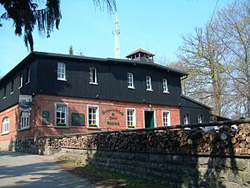
Restaurants: 'Erntekranzbaude' or 'Bergbaude Bieleboh'